 freeflightlab
Well Today I planned to make some videos of testing one of the newest units..
After flying some RC planes in the field to warm up, all of the planes are 3d printed (https://www.eclipson-airplanes.com/airplanes)
It started to rain, in fact my maiden flight of a plane was in the rain.. Super fun, but no paraglider flight testing.
The window we had was from 9-10am.
Weather.. I've devoted a lot of passion and energy since about 2010 into understanding our Earth's processes in greater detail. I like the limits of things, or to imagine where those limits might be..
2008 - Started sailing by repairing hurricane damaged boats and testing them...
2010 - Refocus Carbon Cycle Project at International Space University
2012 - Started Paragliding
2015 - Anticip8 - Weather Analytics Company Startup Incubator - Singularity University
2017 - Express 37' National Champions - Sailing.
2018-2020 - Monark - Weather Analytics, GNSSRO, Global Sensing at Scale | Airbus, Acubed Innovation Center
2020 - BBC Super Powered Eagles / PBS NOVA Eagle Power - Tandem Paragliding with Lloyd Buck
To me weather is a critical part of operating flying vehicles safely, and understanding it is the crux of getting global adoption of autonomy.
You must consider to your fullest extent of skill possible/available all risks that are present, or in a different way, potential opportunities for performance gains.
I love to sail and paraglide, both of these use no fuel, only sunlight and wind. Other vehicles can use this mindset to keep flying or to safely launch or land.
The topic of weather, and climate is difficult because it happens at various scales of time and dimension. Ok that sounds crazy, but how do I talk about the tiny flies that float in early morning sun around my plants in the same context as wind driven sea spray impacting the formation and trajectory of a hurricane.
This is also why it has been difficult to fully resolve the physics that go into computational analysis of weather and Earth processes. Things must be parameterized to be able to get an answer before the event occurs. Where is this limit..
There is a great statement from the book '2081 A hopeful view of the Human Future' - Gerard K O'Neill
-Von Neumann imagined that by the 1980s a very big electronic computer would be able to predict weather quite accurately. But weather prediction isn't a great deal better now than it was several decades ago. The atmosphere of Earth is enormous, a billion cubic miles in volume, and it reacts to sunlight, cloud cover, the exchange of heat with the oceans and the land, and even to the particles streaming off the sun. To make perfect predictions we'd need not only a computer of infinite speed and memory, but a system of sensing devices at every latitude, longitude, and altitude in the atmosphere, measuring at every moment the temperature, pressure, humidity, wind, airborne dust, and perhaps still other variables. In fact, measurements are only taken twice daily, and only at wildly scattered geographic locations. Over great areas of oceans, desert, and polar regions there are almost none at all. In reality, weather prediction can be affected more by a governmental decision to economize the number of air samples taken per day than by the advances in the speed and memory capacity of computers ------ 1980
Since 1980 there have been significant improvements in both ends of sensing and forecast skill. We have not rea yet reached the limit of what is possible. Many "advanced" uav projects and high altitude platforms focus on the technical aspects of design, and offering capability to customers. We see this is difficult as Loon was just shut down. The difference between 1000 platforms, and 10 are how well do you understand your ability to navigate and maintain flight aloft. This skill is massively correlated to weather and environment. Groups like Perlan 2.0 and HAPS platforms are discovering new phenomena in the high altitudes that are novel and yet to be understood. Sail drones are filling gaps in the oceans.. We all have a long way to go, and are far from the limit... So lets get into it!! The best part is each small improvement has cascading benefits to the well being of life on Earth.. bold statement.. maybe not.. Start to think about it.. from understanding drought cycles, as the Earth is dynamic, our ability to understand how what we observe will impact the near and potentially far future... we can better manage resources.
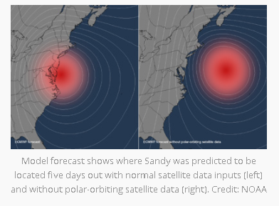
A good example of this is from Planet IQ. They did a study on hurricane Sandy, and noted that if the space assets of polar orbiting satellites were just a few less. 3 or so.. The forecast would have predicted that Sandy never made landfall and went out to sea.. we know this to not be true as what happened. Here is the source.
We are also finding new ways of discovering patterns and establishing models using different types of machine learning strategies .
Depending on what you care about and when; systems have gotten quite good.
For paragliding I use the HRRR and ECMWF forecasts, for sailing I use a custom one called sail tactics (Saildrones bought them). Many tools like https://www.windy.com/ help visualize both directional trends, and strength trends. I mostly look for timing and magnitude. When you are actually out in the field.. there is some correction.. That is the idea behind sensors and data assimilation. The forecast says 5mph, and 60degrees, but its 6mph and 62 degrees. Having TRUTH data in a timely fashion can help to tune, and re-establish warm start forecasts.
If weather is interesting to you please take a look at these free modules.. https://www.meted.ucar.edu/index.php You can sign up and learn basic to advanced meteorological concepts for free!!!
We need more sensing!!!!!
Ill give an example. GNSS-RO measurements are used in data assimilation to improve weather forecasts today. Currently NOAA is seeking 20,000 measurements per day. They capture about 2,000-5,000 depending on a few different satellite constellations and some trial commercial partners. Over the last few years trial programs have gone from $100k, 700k, 1-3M.. now it is expected that these programs will be funded in the order of 22-24 Million dollars per year. https://spacenews.com/radio-occultation-ams-2020/
For weather balloons almost 1M dollars is spent per day releasing 2800 balloons globally. There are also aircraft based sensing programs AMDAR is one. There needs to be a lot more humidity measurements taken globally.
How can we increase sensing in a way that doesn't create trash, can recover expensive sensing systems, and or is bio-degradable and cheap...
A group that cares a lot about integrating new datasets into improving forecasts is JCSDA
or the Joint Center for Satellite Data Assimilation. They are not constrained to just space based sensing.
I can say a lot about this, but its part of the driver. I love to fly in thermals, they are moments of time, little bubbles of warm air, released by a tree, or a sheep running around.. Its crazy. No automated system gets to play like this yet.. When they do.. It will seem like magic, when its just Earth physics. ;)
Discussions
Become a Hackaday.io Member
Create an account to leave a comment. Already have an account? Log In.