 Richard
-
Collision avoidance of factory pedestrians and vehicles
04/19/2021 at 15:59 • 0 commentsThe Huaxing Intelligent Forklift Collision Avoidance System solution is a human-vehicle collision avoidance solution based on UWBLOC wireless pulse ranging technology. I will slowly finish how this solution is implemented.
First of all, let me talk about its basic underlying logic. Wireless pulses are electromagnetic waves. The speed of pulses flying in the air is equal to the speed of light. The distance can be obtained by multiplying the speed of light by time. This is an arithmetic problem known in middle school. Distance = speed * time.
![]()
We calculate the distance based on the time of the wireless pulse flying in the air.
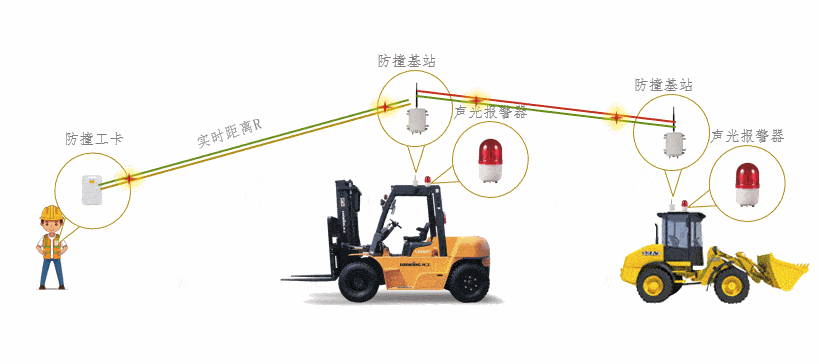
Personnel need to wear a kind of pulse signal transmitting equipment, we call it an anti-collision tag. The anti-collision tag worn by personnel will transmit signal pulses at a pre-set frequency. After the signal pulse is sent out, it will be received by the signal installed on the car. When the equipment receives it, the pulse receiving device installed on the car is called an anti-collision base station, as shown in the figure below. The anti-collision base station will calculate the distance between itself and the anti-collision tag after receiving the pulse sent by the tag.
![]()
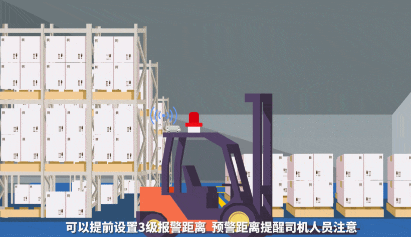
With the distance between the anti-collision base station and the anti-collision tag, we can realize the function of anti-collision between people and vehicles. We can set an estimated distance and an anti-collision distance in advance. When the positions of people and vehicles are less than what we set in advance Warning distance or collision avoidance distance, then we need to remind people and the driver of the vehicle to pay attention. The collision avoidance base station can be connected with an audible and visual alarm. When the distance between the personnel and the vehicle is less than the alarm distance, the audible and visual alarm can be turned on. , Sound and light can remind drivers and personnel to avoid danger.
![]()
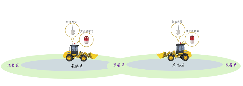
This anti-collision system is also suitable for the anti-collision between vehicles, and the principle here is exactly the same as the above-mentioned human-vehicle anti-collision principle.
![]()
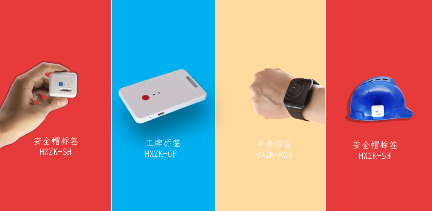
The tags worn by the personnel have the following forms, which can be fixed on the helmet, or worn on the hand or on the chest. You can choose different wearing styles according to different application scenarios.
![]()
The internal structure of the anti-collision base station is supplemented. The real-time distance between people and vehicles or vehicles can be output through 485. There are 2 relays inside, corresponding to 2 normally open and 2 normally closed contacts, which are controlled by the opening and closing of the relay The sound and light alarm is based on this principle.
![]()
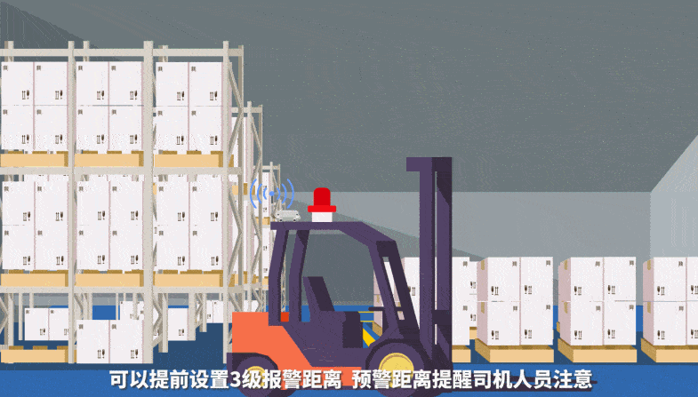
Below we use several animation screens to make it easier for you to understand this anti-collision system scheme. The following is a schematic diagram of car anti-collision animation.
![]()
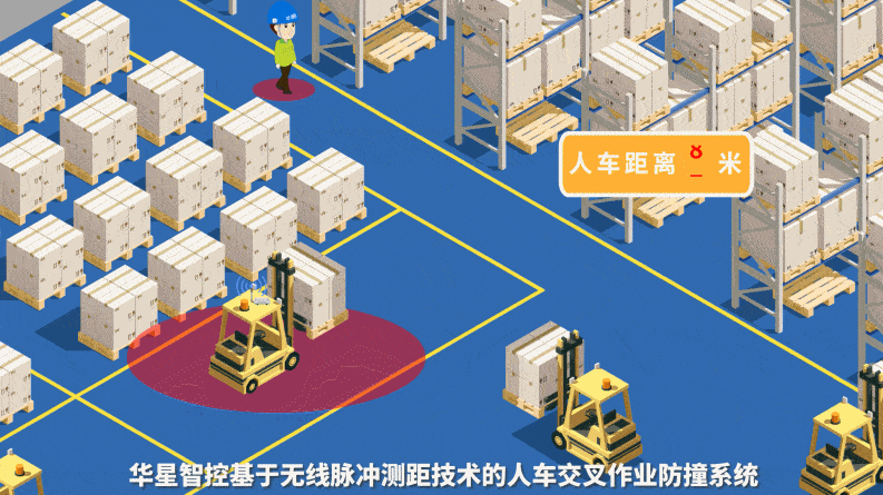
The following figure shows the schematic diagram of the anti-collision animation of people and vehicles.
![]()
![]()
![]()
If you are concerned about the collision avoidance distance between people and vehicles, let me tell you that the collision avoidance sensing distance of people and vehicles is greater than 100 meters, and the sensing distance of vehicles is greater than 500 meters. Such a distance should satisfy most application scenarios. Finally, let's take a look at an actual installation photo, otherwise you might suspect that I didn't make this kind of project.
![]()
-
UWB+GPS Converged Equipment
04/18/2021 at 13:16 • 0 commentsProduct features: support Beidou differential positioning and UWB positioning, automatic switching between indoor and outdoor high-precision positioning, positioning accuracy up to 2 cm outdoors, up to 10 cm indoor positioning accuracy, IP67 protection level, industrial-grade design.
![]()
![]()
![]()
![]()
![]()
Product parameter
Device model
HXZK-URT
Charging voltage
DC5V/1A
Indicators
4, 1 RTK indicator, 1 power indicator, 1 4G signal indicator , 1 UWB indicator light
Output power
-24dBmM/MHz
Life time (UWB mode)
>2 months
Life time (differential mode)
>10 hours
Charging port
Magnetic charging
battery
3000mAh
UWB working frequency band
3.75-4.25GHz
UWB refresh rate
1-100HZ
G refresh frequency
1-20 HZ
Satellite system
北斗+GPS
Differential accuracy
Plane accuracy:±(30 + 1×10⁻⁶×D) mm Elevation accuracy:±(50+ 1×10⁻⁶×D) mm
Channel bandwidth
500MHz
UWB antenna
Built-in omnidirectional antenna
GPS antenna
External spiral rod antenna
UWB Location Algorithm
support TOF/TDOA/RTK
UWB positioning accuracy
10Cm (unobstructed)
UWBCommunication distance
>300m
Size
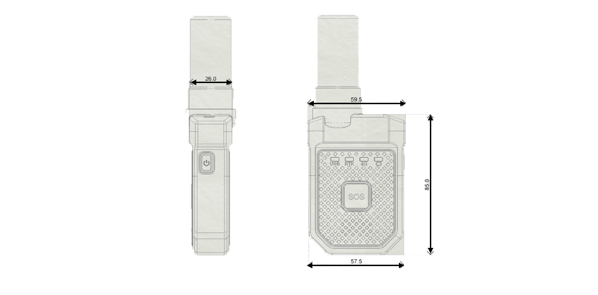
57.5x85x59.5
weight / g
300
Operating temperature
-20℃~65℃
Working humidity
0%~90% No condensation
Protection level
IP67
Dormant
Smart sleep
ROHS
compatible
SOS alarm
support
Low battery warning
support
Automatic sleep and wake
support
-
Exhibition Position
04/14/2021 at 05:46 • 0 commentsHuaxing Intelligent Control UWBLOC positioning system adopts self-developed wireless pulse ranging technology to achieve precise positioning of exhibition hall personnel and exhibits. The positioning accuracy is better than 30 cm. By setting the base station on the positioning site, the target object that needs to be positioned is worn Positioning tags can realize real-time accurate positioning of the target object. Based on this, various functions can be expanded to realize rich functional applications.
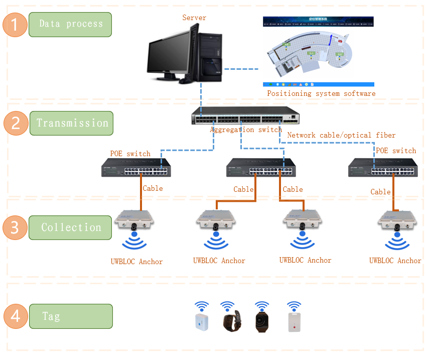
The entire positioning system consists of 3 parts, 1. is the data collection layer (including positioning tags and positioning base stations); 2. the data transmission layer; 3. is the data processing layer (mainly including server and positioning platform software).
![]()
Tag
![]()
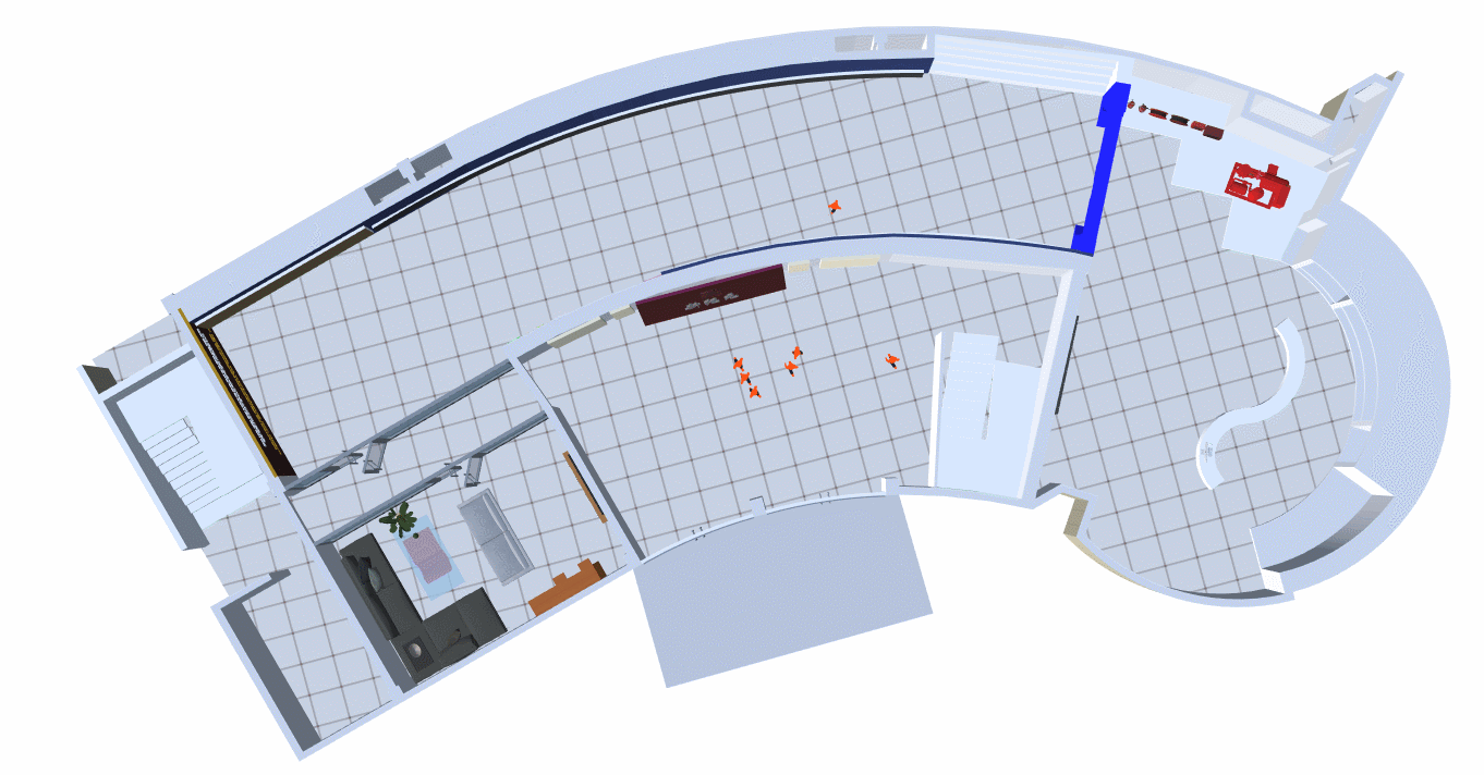
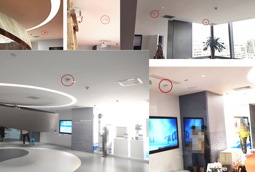
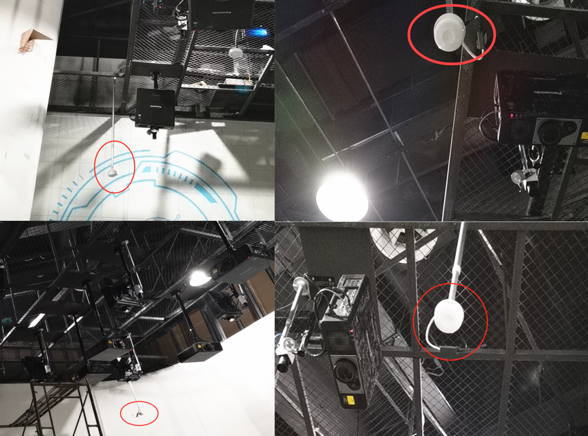
As shown in the figure below, by arranging several positioning base stations in the area where positioning is required, personnel can wear positioning tags to achieve precise positioning of personnel.
![]()
System function introduction
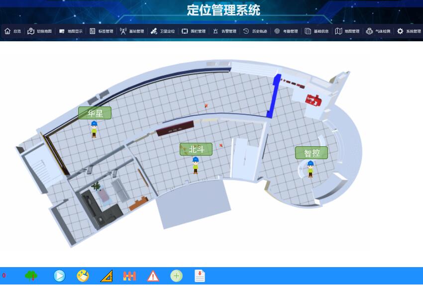
The global display on the map is the location of the target object, the location is updated in real time in milliseconds, and the number of various people in the area is automatically counted.
![]()
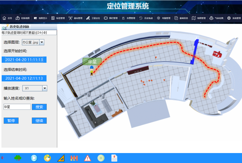
Historical trajectory playback function, you can query the historical movement trajectory data of personnel in any period of time.
![]()
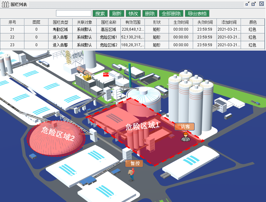
The electronic fence can be drawn to any area through the software, and the dangerous alarm can be triggered when the unauthorized personnel approach.
![]()
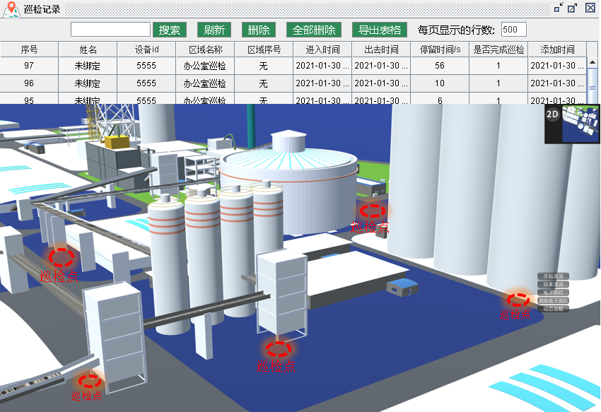
The automatic inspection record function can record the time when the personnel arrive at the inspection point, the statistics of the stay time at the inspection point, whether the inspection is completed, and whether the inspection statistics are generated according to the planning requirements and the report records are generated.
![]()
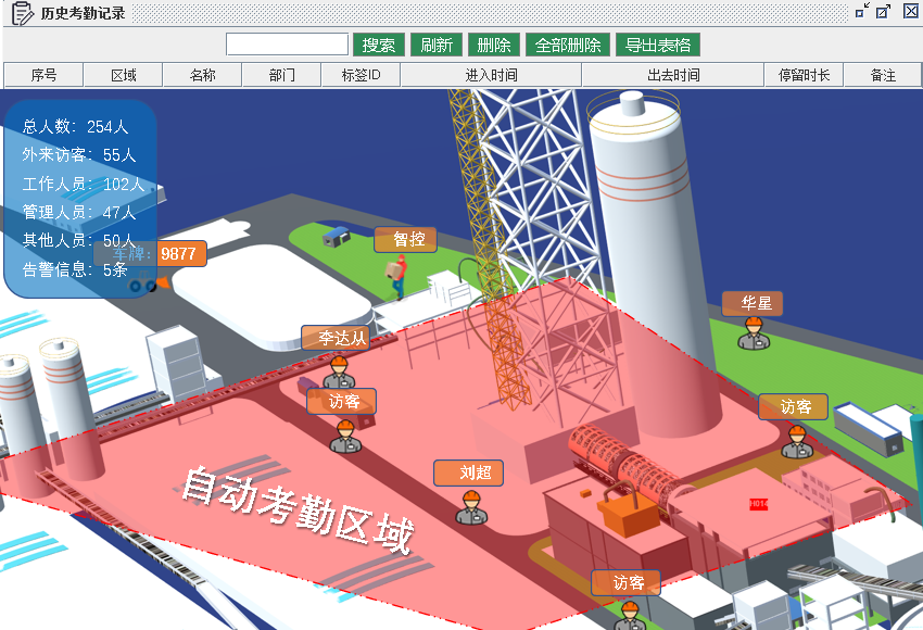
The automatic attendance area can be arbitrarily delimited by the software, personnel entering and exiting the attendance area can complete the attendance function without perception, record personnel attendance information, and generate attendance reports.
![]()
The video linkage function can specify to track a certain target object, and can link the video screen to realize the automatic fusion function of personnel positioning and camera.
![]()
The location label has a one-key call for help button. In an emergency, you can use the one-key call for help button to call for help. After receiving the information, the rescuer can quickly locate and arrive at the scene of the incident for rescue in time.
![]()
The system also provides convenient secondary development functions, development data interfaces, and rapid development docking SDK to realize data docking between positioning systems and other platforms.
![]()
Some application cases
![]()
![]()
![]()
![]()
This user joined on 11/07/2018.
My Pages


Things I've Built
Fast LED Screen With Refreshing Rate Up To 10,000
This screen is invented by me in Institute of Biophysics, Chinese Academy of Science. It is used to study the high visual perception speed of fruit fly. This screen can refresh 10k times/s. This video is taken by a high-speed camera with 1k fps.
Ninebot Plus self-balancing scooter
Consumer electronics with annual sales of more than 100,000. I am responsible for the auto-following function.
 Lutetium
 Daniel Wiegert